PDT: An Advanced Imagery Exploitation Tool
for the Defense Market
Use of Visualization Technology to Support Civilian and Military Decision-Making is Increasing...
High-resolution spatial and intelligence data such as maps, terrain overlays, aerial images, cultural
information and hyperspectral data often provides the geographic framework upon which tactical options
are evaluated. As data density continues to increase and display screens get smaller, innovations in
visualization software and data interaction are necessary to overcome data claustrophobia and to ensure
timely, accurate military decisions are being made.
Key Visualization Considerations Include:
-
Intuitive search tools for efficient access to relevant information in high-density
data and multiple layers of information
-
Real-time visualization to address specialized analysis, targeting and situational awareness needs
-
New ways to collaborate and communicate information that will lead to accuracy gains
and more informed decisions for both command and control and troops in the field
-
Productivity enhancing tools for existing imagery analyst workflow tasks such as
battle damage assessment, change detection, multi-image comparisons, and distance/target
measurement
Existing Tools are Becoming Inadequate and Inefficient...
An image analyst spends a great deal of time analyzing high-resolution geospatial data sets and satellite
images that have been compressed to fit on a computer monitor. Working with these large amounts of information
on a limited-size display presents the challenge of viewing detailed regions of interest and understanding how
this information relates to the rest of the data set that is too big to fit on the screen. Using existing
viewing tools, imagery analysts can zoom in and out to resolve the loss of context, but this can leave the
user disoriented and can cause inefficiencies and distractions within the workflow process as they waste
valuable time trying to relocate navigational cues. "Where am I?" is a common question.
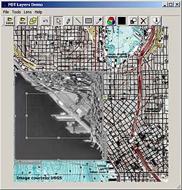
PDT for Detail-in-Context Visualization - A Solution to the Screen Real Estate Problem...
Pliable Display Technology (PDT) by IDELIX is a visualization technology that can be tightly integrated
within GIS, Remote Sensing, Imagery Analysis and Geopositioning technologies to address many of the
considerations outlined above. PDT is a visualization solution to the growing challenge of working with
high-density data sets and images on a limited size screen display. The PDT lens can be configured, moved
and manipulated in real time, resulting in a "virtual lens". As the PDT lens moves over an image, it
magnifies a subset of data while keeping the connectivity to the rest of the space - the result is
"detail-in-context" viewing, and the ability to take full advantage of the information presented regardless
of the platform, device or screen size being used.
The PDT lens enables users to view the level of detail they require and manipulate this information while
remaining seamlessly connected to the contextual surroundings. Common imagery search tasks such as change
detection, mark-up and feature extraction, hyperspectral analysis, and the interpretation of multiple layers
of geo-coded data can be performed with greater efficiency as recurring zooming and panning steps are replaced
by Pliable Display Technology's "detail-in-context" data visualization functionality.
Exploit and Disseminate Mission-critical Information...
There are many features unique to PDT that will enhance current efforts to exploit and disseminate
mission-critical information. PDT can directly impact the efficiency and accuracy of tasks such as:
-
Change Detection
-
Battle Damage Assessment
-
Situational Awareness in the Battlefield
-
Tactical Communication and Collaboration
-
Targeting via Forward Observation for Artillery
-
Terrain Analysis and Feature Extraction
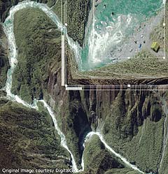
PDT: Increasing Situational Awareness and Measurement Accuracy...
The ability to accurately mark key navigational cues, communicate battlefield details such as troop
positioning, identify civilians, and detect unique landmarks are of vital importance to the success of
military efforts. The use of current viewing tools such as inset views and separate views hide data
directly next to them and result in a disconnect between an area of interest and the underlying information.
PDT provides a seamless connection between the area of interest being magnified and the underlying information.
Users have the ability to view the "whole picture" through a real-time lens resulting in increased situational
awareness and rapid visualization of new information and regions. By replacing the disconnect of information
found in inset and separate views with the continuous flow of information found in PDT, accuracy of data
interpretation increases and errors in distance and target measurement are minimized.
PDT: Increasing the Efficiency of Multi-Image Comparison...
Comparison of multi-images and layers of data that show information such as time successions, a variation
of data types, hyperspectral data, or the before and the aftermath of a battle region can be a cumbersome,
overwhelming process. PDT can help you view and edit multiple layers of "stacked" information more efficiently
and accurately. The PDT lens enables you to roam your image set viewing a secondary layer in the lens. The
layer appearing within the lens, such as an aerial image or a secondary level of detail, can give pertinent
analysis information. The second layer can be geo-coded and aligned with an actual map of the area making
additional information such as coordinates available and giving a more informed view of your area of interest.
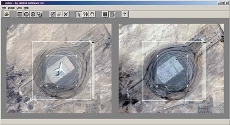
As an alternative to applying PDT lenses on multi-layered data, one can "chain" and "synchronize" the
movement of multiple PDT lenses across image sets that have been placed side-by-side. This provides image
analysts the ability to correlate multiple image sets simultaneously with the power of detail-in-context
inspection to quickly compare regions of interest in tasks such as change detection. Chained lenses can
also be extended to satellite images geo-referenced with vector maps. Instead of overlaying a satellite
image on a map, images can be displayed side-by-side, with chained lenses enabling detailed simultaneous
views of the same geo-referenced region.
PDT for Mobile Forces...
The combination of GPS with GIS technologies and handheld devices has created knowledge-enabled, mobile
forces. Every soldier's location will soon be mapped on a network and displayed on each individual's wireless
device providing situational awareness to everyone in the field. Wireless devices enabling mobile and informed
populations have enormous efficiency and lifesaving potential. The small screen sizes of handheld devices
pose a visualization challenge that is answered by PDT's detail-in-context viewing capabilities, providing
complete situational awareness where and when you need it.
Find out more
For a list of the Features and Benefits of PDT and PDT 3d, see the
PDT Product Sheets
.
For more technical detail on PDT, read our
White Papers
or
Technical Descriptions
.

